
Tracing an Adams County Street
A useful street directory search begins with the exact string supplied by the source. Preserve the number, directional prefix, street name, suffix, unit, city, and ZIP before normalizing anything. Then move from a current parcel key to a public map and a document trail. The county's records are linked by account, parcel, reception, case, voter, and permit keys, not by one universal resident field.
The sequence below is a practical street-by-street workflow. It can establish a parcel, an owner or mailing field, a named recorded party, a permit record, or a historical address clue. It cannot turn every person connected with a property into a confirmed current resident.
- Run the original address through Adams County Property Search, then try a street-range search if the exact form fails.
- Save ACCOUNTNO, PARCELNB, account type, status, situs, subdivision, block, lot, and any legal description.
- Place the parcel in the Basic or Advanced Adams GIS viewer and note adjacent parcels, road labels, and jurisdiction layers.
- Use the parcel's sales and reception clues to search Landmark by grantor, grantee, reception number, date, or document mode.
- Check the relevant city permit layer, voter product, ZIP label, or reverse directory only after the address and jurisdiction are clear.
Adams County Street Directory Records
The Adams County street directory is assembled from records keyed to an address, parcel, person, or named transaction. The Assessor is the current parcel bridge. GIS adds geometry and jurisdiction. Landmark supplies recorded instruments. Elections offers a limited public registration path. Municipal permit layers add a city-specific work history. Historical reverse directories can place a household at a prior date. Each row below has a different answer and a different access channel.
| Record set | Keeper | What it can show | Access |
|---|---|---|---|
| Property account/export | Adams Assessor | Parcel, situs, owner or mailing fields, legal and sales clues | Property Search and dated downloads |
| Parcel and road map | County GIS / IT | Adjacent parcels, roads, layers, districts, map context | Basic, Advanced, Eye on Adams, open data |
| Deeds, liens, plats | Clerk & Recorder | Named parties, reception numbers, legal descriptions | Landmark, email, mail, walk-in |
| Voter records | Adams Elections / Colorado SOS | Authorized public registration fields | Four-field lookup or dated list product |
| Building permits | City department | Work, status, date, legal owner, address and parcel fields | City portal or written request |
The chain is strongest when a parcel number joins the assessor export to a recorded reception number or a municipal permit PIN. A street label alone is weaker because postal city, municipality, county boundary, and historical directory place name can differ.
Adams County Property Records
The Assessor's documented search bar accepts parcel number, account number, owner, address, and county permit number. Account-type and street-range filters help when a long street returns several accounts. Research could not inspect a populated result card because the live application returned a Cloudflare response. Use the official file layouts as a field map, and label every export with its date.
| Field or control | Street-level use |
|---|---|
| Parcel number | Stable county parcel key for a map or account handoff. |
| Account number | Joins Account Master, Name/Address, Legal, Sales, and value tables. |
| Owner and address | Tests a name or situs input; never assume owner equals occupant. |
| County permit number | Connects an identified permit to the county account route. |
| Account type | Separates account categories, including records that do not behave like a standard parcel. |
| Street range | Narrows a street search before comparing individual accounts. |
When a result appears, retain STREETNO, STREETPREDIR, STREETNAME, STREETSUF, STREETPOSTDIR, UNITNAME, LOCCITY, LOCZIP, SUBCODE, SUBNAME, BLOCK, and LOT. The Name/Address file has PRIMARYOWNER, NAME1, NAME2, ADDRESS1, ADDRESS2, CITY, STATE, and ZIPCODE. Keeping both field groups prevents a mailing address from being mistaken for the parcel's situs.
Use the Adams County Property Search and the Assessor Maps and Data page as separate routes. One is a live search; the other supplies dated downloadable files and layouts.
Note: The assessor page documents search fields and filters, but not every populated result-card field.
Situs and Mailing in Adams County
Situs means the place assigned to the parcel. A mailing address is where notices or correspondence are sent. Adams County's Admin file holds street components and local city or ZIP fields, while the Name/Address table holds owner and mailing lines. They may match, but they need not. A rural route, condominium account, business name, or off-site owner can make the difference important.
Keep the source string beside the normalized version. Compare the assessor's street number and suffix with the GIS road label, then compare the mailing line separately. If an old deed uses a former name, use the legal description, subdivision, block and lot, parcel number, or reception number to bridge it. Adams research found no verified countywide renumbering project or old/new street table, so matching numbers alone are not enough.
- Situs address
- The address assigned to the parcel or improvement in a property system.
- Mailing address
- The delivery line attached to an owner or account, which may be elsewhere.
- Parcel
- A mapped property unit identified by PARCELNB and a legal description.
- Plat
- A recorded or submitted map that describes lots, roads, boundaries, and survey relationships.
Adams County Street Map Layers
The county Basic Web Map is concise, while the Advanced Web Map is more comprehensive. The Eye on Adams layers add building permits, code violations, and land-use cases, with filters and alerts for neighborhoods or special districts in unincorporated Adams County. A map inspection should show the target parcel, adjoining polygons, road labels, and the jurisdiction or district layer when available.
The county GIS disclaimer matters. Map data can contain errors or omissions, and a visible point is not a survey or title opinion. Preserve the viewer name, layer names, map extent, and inspection date. If a parcel popup is unavailable, use the parcel number from the assessor file and contact GIS rather than filling the gap with a guess.
Official map access runs through the Adams Basic Web Map, the Advanced Web Map, and the county GIS open-data catalog. The catalog carries dataset-specific dates and field notes.
Adjacent Adams County Parcels
For a block-sized street directory search, begin at one known parcel and pan along the street segment. Keep parcel and road layers on, then note the next parcel numbers, subdivision or lot clues, municipal boundary, special district, and any permit or land-use layer. Use the resulting set as candidates for separate parcel checks, not as a ready-made list of nearby households.
A practical process is:
- Address to parcel: save the assessor account and parcel number.
- Parcel to map: confirm the road, adjacent polygons, municipality, and county layer.
- Parcel to owner field: compare each account's owner and mailing fields without inferring occupancy.
- Owner to document: test the grantor-grantee index with names and reception clues.
- Block to community: check a district, permit, or neighborhood-group boundary for context.
The unattended map inspection did not expose a reliable distance or buffer control. A selected parcel set should therefore be described as a map-based candidate set and dated.
Note: A map-selected adjacent parcel set is a research candidate list, not a public household roster.
Adams County Deed Records Trail
Landmark is grantor-grantee indexed, not tract indexed. Start with the assessor SALES row if available. Preserve RECPTNO, BOOK, PAGE, grantor, grantee, document date, sale date, and document code. Search a known reception number first. If that is missing, use the parties, approximate date, document mode, or legal search. Read the legal description before deciding that two street strings describe the same land.
The county's recorded-document viewer exposes Name, Document, Book/Page, Consideration, date range, Reception Number, Legal Search, and Quick Search. Ordinary copies can be printed, downloaded, or requested by email. Certified copies require a phone or in-person route. A plat or subdivision filing can expose a reception-number bridge, but a filing packet is not the deed itself and does not prove who occupies a parcel.
The Adams County Landmark landing page shows the disclaimer and search modes used for the street directory workflow. This capture is the source checkpoint for the recorded-document route.
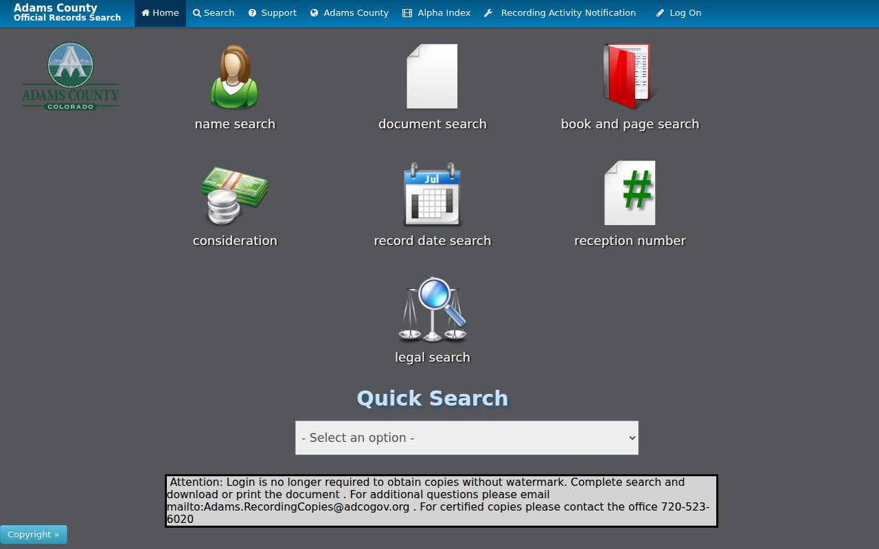
The capture makes the difference between a public index, a document image, and a certified copy visible before a request is placed.
Recording is $43 per document from July 1, 2025. Ordinary copies are $0.25 per page, and certified copies add $1 per document. The Recording Department accepts mail at PO Box 5012, Brighton, CO 80601, delivery at Suite E2400, and walk-in service during published hours.
Adams County Permit Layers
Municipal permits are city records, even when a street has an Adams County mailing label. Thornton's official ArcGIS service separates Building Permits from 1993 through 2017 and Building Permits from 2017 to the present. The service supports query, GeoJSON, PBF, pagination, sorting, statistics, and distance controls. It exposes fields such as permit number, status, dates, description, legal owner, address, ZIP, PIN, ADCO_PIN, ward, lot, block, subdivision, and coordinates.
Use the permit number, address, legal description, or parcel/PIN to connect a city record to the county trail. A missing result can mean the wrong municipality, a date outside the layer, a retained paper file, or a field mismatch. Thornton's City Clerk form can accept a property address, document request, date range, and additional items through web and hardcopy, email, fax, or mail routes. Other Adams municipalities need separate custodians.
Do not read a permit contact or legal-owner field as a complete resident list. It records a regulated project and its public fields for a city-defined period.
Adams County Street Names
Address normalization has several failure points: W versus West, a suffix written in full or abbreviated, a unit written as Apt, Unit, or a number sign, a rural route, a highway address, and a city label supplied by USPS rather than a municipal map. Keep every input variant in the research note and test them separately.
Historical directories may use an old road name or a different municipality. A plat may use a legal description while the assessor uses a current situs. The best bridge is a parcel, subdivision, block and lot, reception number, survey, or dated municipal confirmation. Adams research did not identify a verified year for countywide renumbering or renaming, so no old/new equivalence should be asserted from a matching number alone.
When the historical question becomes a household trail, the Adams County city directory collections provide the publisher, year, reverse-directory, and citation context. The street directory remains responsible for the current address-keyed chain.
Note: Adams County research found no verified countywide street-renumbering year or complete old/new street table.
Adams County ZIP Cross-Checks
The county factsheet lists ZIP and post-office labels across a geography that reaches beyond a single city. LOCZIP and ZIPCODE appear in the assessor file layouts. A ZIP is a delivery field, not a parcel jurisdiction, and the assessor page does not document a ZIP filter beyond its address and street-range search controls. USPS offers By Address, By City/State, and Cities by ZIP modes, but its result is delivery guidance rather than identity confirmation.
Record both labels when they disagree: “USPS delivery city,” “assessor mailing ZIP,” “assessor situs city,” and “GIS municipality.” Then contact the relevant county or city address custodian if the boundary still matters. Do not silently change a directory's historical place name to match today's postal label.
Limits of an Adams County Street Directory
An Adams County street directory can show a parcel, owner or mailing field, recorded party, permit record, map layer, voter result, or dated directory entry. It does not create a public roster of every person at an address. Household members, unlisted people, protected voters, utility customers, and confidential vehicle records are not supplied by the county street chain. An owner can live elsewhere, and a recorded party can be historical.
Lawful use. Use street and address records for personal research, genealogy, local history, civic questions, or safety awareness. Do not use a result to stalk, harass, intimidate, or harm another person.
When the purpose changes from a street to one named person, use the Adams County resident lookup and apply two independent anchors. Preserve the source date and phrase a negative result as “not found in this search,” never as proof that a person or record does not exist.